
Key takeaways
- A travel time map (or isochrone map) shows every area you can reach from a starting point within a set time: e.g. everywhere within a 20-minute drive, based on real roads and speed limits, not a straight-line circle.
- It answers one question precisely: “Where can I get to in X minutes?” by car, bike, or on foot.
- Unlike a radius (distance) circle, a travel time map follows the actual road network, so it reflects how people really move.
- Businesses use travel time maps for site selection, franchise territory design, delivery and logistics optimization, and targeted marketing.
- With Smappen, you can draw a travel time map for free in under a minute and instantly overlay population and business data on the area.
Discover Smappen’s innovative travel time map tool that lets you draw isochrone maps—visual representations of how far you can travel in a set time.
Whether you’re planning your daily commute, scouting the best location for your business, or finding the perfect neighborhood, our interactive tool provides reliable and up-to-date data, different types of areas, and actionable insights to help you make smarter decisions.
How Smappen calculates travel time
Drive time... and more!
Depending on the mode of transportation you pick, Smappen looks at lots of criteria (speed limit on each type of road – city, countryside, highway, etc., and draws the area that you can reach when travelling the specified distance or time (minutes or hours).
These travel-time areas are also called isochrones or catchment areas.
Maps based on travel time
By car
By bicycle
On foot
Travel time map vs. radius map: what's the difference?
A radius map draws a perfect circle a fixed distance from a point and ignores roads. A travel time map draws the area reachable in a fixed time along the real road network, far more accurate for catchment analysis.
| Travel time map (isochrone) | Radius / distance map | |
|---|---|---|
| What it measures | Time to travel (e.g. 15 min) | Straight-line distance (e.g. 5 mi) |
| Follows real roads? | Yes | No |
| Reflects how people move? | Yes | No |
| Best for | Catchment, site selection, territories | Quick, rough coverage view |
| Transport modes | Car, bike, on foot | N/A (geometric circle) |
A driving-radius map tool
Use Smappen to draw driving radius maps and get the right answers. Make data-driven decisions with this easy-to-use tool!
Choose the best location for your business
Smappen provides you with population data on your areas, so that you know which is the best location for your business.
Optimize logistics (delivery, pricing, technicians, etc.)
Save time and money by providing the best-optimized areas for your deliveries or technicians.
Plan your journey, move or visit friends
Just moved to a new city? Friends all over the country? Find where you can get to in a given travel time.
Target your marketing campaigns
Easily extract zip codes from your areas, for the best-targeted campaigns.
Find your next home or job
Want to move, but don’t want to be too far away from your place of work? Smappen shows you the ideal geographic area where you should house-hunt, with a variety of home-to-workplace travel times.
How to Create Travel Time Maps?
Travel time is something that affects us all in many ways, whether it’s how we get to work, the accessibility of healthcare, or even how we plan a fun day out. Being able to understand and visualize travel time can make a huge difference in how we navigate our lives and make decisions.
Behind the scenes, technology and data come together to create what we call “travel time maps.” These maps are more than just visuals – they’re helpful tools that guide us in making choices about where to go, how to get there, and how long it might take.
In this easy-to-follow guide, we’ll explore what travel time is, how it’s mapped out, and how you can use this information to make your day-to-day life more efficient and enjoyable.
Let’s get started!
What is Travel Time?
At its simplest, travel time is how long it takes to go from one place to another. But it’s much more than just minutes or hours on the clock – it impacts our daily routines and decisions. It influences everything from our morning commute to how we spend our free time.
Several factors affect travel time, including your mode of transport, whether walking, driving, or taking public transport, plays a role.
Let’s take a look at how they’re created.
Creating Travel Time Maps
Travel time maps rely on a mix of technology and data. Tools like Smappen, a popular geomarketing platform, use geographic information systems (GIS) to gather data from various sources – traffic info, transportation networks, location data – to create these maps.
Smappen helps people and businesses make informed decisions by calculating and visualizing travel times in an intuitive way. Here’s how you can create this kind of map using Smappen:
- Get Started: Visit smappen.com/app/—our interface is intuitive and user-friendly.
- Enter your starting point: Input your current address or location.
- Set your parameters: Select your travel time (minutes or hours) and choose your mode of transportation—by car, bicycle, or on foot.
- Visualize your area: Click “Calculate” to instantly generate your isochrone map and explore the reach of your journey.
Voila! Your travel time map is ready. For more in-depth help, check out the tutorials on Smappen’s site.
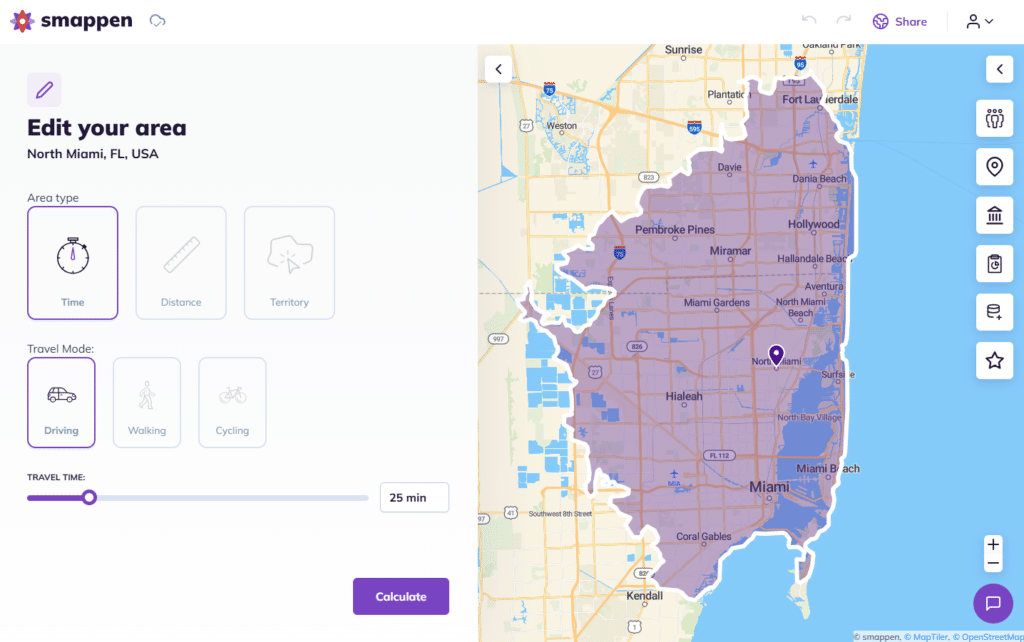
Here’s how it looks on Smappen:
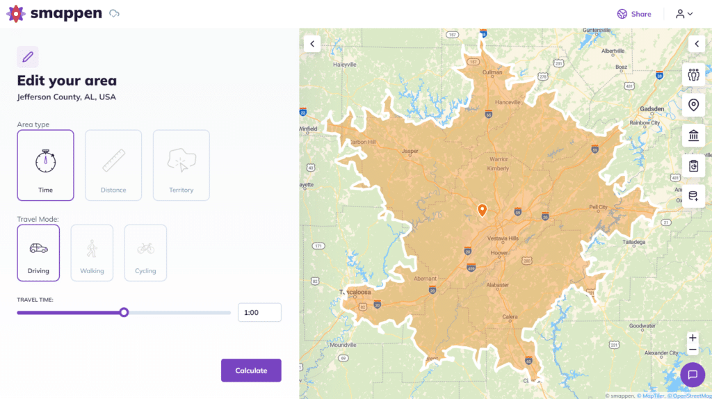
I enter my company’s or site location and create a 1-hour travel zone around the reference point.
A real example: choosing where to open a store
Say you’re scouting a location for a new coffee shop and you want most customers within a 10-minute drive. Drop an address into Smappen, set the travel time to 10 minutes, choose by car, and click Calculate. Smappen draws the exact area reachable in 10 minutes along the road network.
Now add the data layer: turn on population to see how many people live inside that area, and business data to spot competitors already operating there.
Want to compare two addresses? Draw a second 10-minute area and put them side by side. In a couple of minutes you’ve replaced guesswork with a data-backed catchment comparison — the same workflow franchisors use to design and defend territories.
Interpreting Travel Time Maps
Benefits for Users and Businesses
Our travel time maps aren’t just for planning personal trips—they’re a valuable asset for businesses too. For example, when choosing a new store location, our maps reveal where potential customers are within a convenient driving time. Likewise, logistics companies can optimize delivery routes, and marketers can target campaigns based on clearly defined catchment areas.
Thanks to user-friendly platforms like Smappen, accessing travel time information is easier than ever. With just a few clicks, you can zoom in on your map, explore different areas, and get a clear picture of travel times in your chosen region. Whether you’re planning your daily commute or deciding where to open a new store, these tools make the process and your day-to-day life a lot simpler!
Customer Satisfaction with Smappen - Travel Time Maps Tool
The UI is the genuine of the platform, it makes it really easy to use and makes everything straightforward.
Ben Gerding, Franchise Development Director at Essential Speech and ABA Therapy
There’s so much data that you can pull from when you draw the maps, like population and business data. You can export everything for reporting and easily categorize your territories.
Angie Honeycutt, Vice President at 1 Tom Plumber
Frequently Asked Questions (FAQ)
A travel time map visually represents how long it takes to travel to different locations from a specific starting point.
Travel time maps use geographic data and routing engines to calculate how far you can travel along real road and transport networks in a given time.
Yes. Smappen offers a free plan that lets you enter a starting location, set a travel time, choose a transport mode (car, bike, or on foot), and instantly generate a travel time map — no credit card required.
Absolutely! Businesses can use travel time maps to identify the best locations for their stores, offices, or distribution centers. These maps help ensure that they’re in areas where customers and employees can easily access their services, leading to better business outcomes.
Create your travel time map with Smappen