I guess you already know… but let me say it again: in today’s business environment, geographical insights play a crucial role in strategic decision-making. Whether you’re planning a franchise expansion, optimizing logistics, or conducting market analysis, understanding the concept of a zip code radius can significantly enhance your operations.
Let’s dive together into the main key aspects and discover how Smappen tool can revolutionize your business strategies! 🚀
Understanding Zip Codes and Postcodes
Zip Codes
They are postal codes used by the United States Postal Service (USPS) to identify specific geographic delivery areas. Each code represents a distinct region, ranging from a small neighborhood to a large city district. For businesses, they are crucial for market segmentation, demographic analysis, and logistics planning.
Postcodes
For our UK audience, postcodes serve a similar function. Managed by the Royal Mail, postcodes help to identify specific geographic areas for efficient mail delivery. Each postcode can cover a street, a part of a street, or even a single address. Businesses in the UK can use postcode data for targeted marketing, logistics optimization, and franchise planning.
Leveraging Zip Code Radius for Business Operations
Franchise area planning
For franchises, determining the optimal locations for new outlets is essential for maximizing market reach and minimizing competition within the brand. Using a zip code radius map, businesses can visualize potential franchise areas, ensuring that new locations are strategically placed to attract the maximum number of customers without overlapping with existing outlets.
With Smappen, you can easily draw a radius around a specific address to explore potential franchise areas. For example, if you’re planning to open a new coffee shop, you can use Smappen to visualize a radius around a specific area, identifying zip code and then neighborhoods and competition.
Contracting franchise areas
Sometimes, businesses need to contract or downsize their franchise areas to focus on more profitable regions or reduce operational costs. Using a zip code radius map, businesses can identify which areas are underperforming or overlap with other franchises, making it easier to make data-driven decisions about which areas to contract.
For example, a fast-food chain might notice that certain outlets within a 3-mile radius of zip code 77002 are underperforming due to market saturation. Using Smappen, the business can analyze customer distribution and competition within this radius, allowing them to make informed decisions about consolidating or closing certain outlets to optimize their overall performance.
Optimizing logistics
Efficient logistics are the backbone of any successful business. Understanding the distribution of your customers and warehouses can help streamline delivery routes and reduce operational costs. By mapping out zip code radii, businesses can identify the most efficient delivery zones and plan optimal routes.
Smappen’s features allows logistics managers to calculate precise delivery zones based on zip codes.
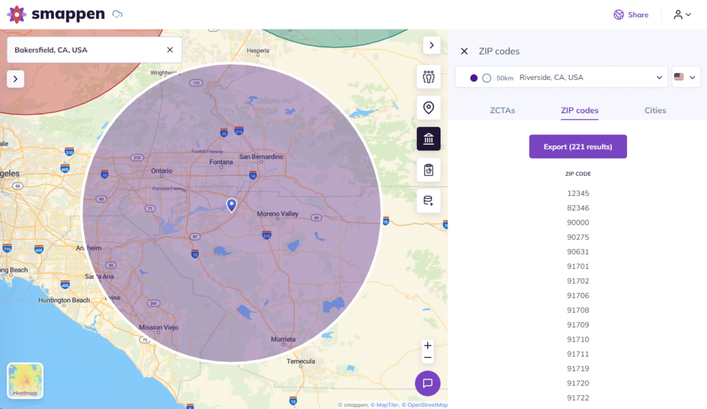
Utilizing radius maps and map calculators
Radius maps are powerful tools for visualizing geographic data and making informed business decisions. By drawing a radius around a specific zip code, businesses can analyze various factors such as population density, customer distribution, and market potential.
Smappen’s map calculator feature takes this a step further by providing detailed insights and analytics. For example, if you want to analyze the potential customer base within a 15-mile radius of zip code 10001, smappen’s map calculator can provide data on population demographics, average income levels, and competitor locations.
This information is invaluable for targeted marketing campaigns and strategic planning.
Practical Examples with Smappen
Example 1: Expanding a retail chain
A retail chain planning to expand into new regions can use Smappen to identify the most promising zones. By drawing radii around potential locations, the business can assess factors such as nearby competitors, population density, and accessibility. This helps in selecting the best sites for stores, ensuring maximum customer reach and profitability.
Example 2: Improving delivery services
A food delivery service aiming to optimize its delivery zones can utilize Smappen to map out zip code radii around its kitchens. By analyzing the geographic distribution of customers, the service can design efficient delivery routes that minimize travel time and costs. This leads to faster deliveries and improved customer satisfaction.
Example 3: Targeted marketing campaigns
A marketing agency working for a local business can use Smappen to create targeted marketing campaigns. By identifying zip codes with a high concentration of potential customers, the agency can design localized advertising strategies that yield higher conversion rates. Smappen’s detailed demographic data ensures that marketing efforts are precisely targeted.
Example 4: Contracting franchise areas
A fitness franchise with multiple outlets might realize that some locations are not performing as expected. Using Smappen, they can draw a 5-mile radius around each franchise in zip code 60601 and analyze customer density, competition, and revenue data. If certain areas show low performance and high competition, the franchise can make data-driven decisions to contract these areas, focusing resources on more profitable locations. This strategic contraction helps optimize operational costs and boosts overall franchise performance.
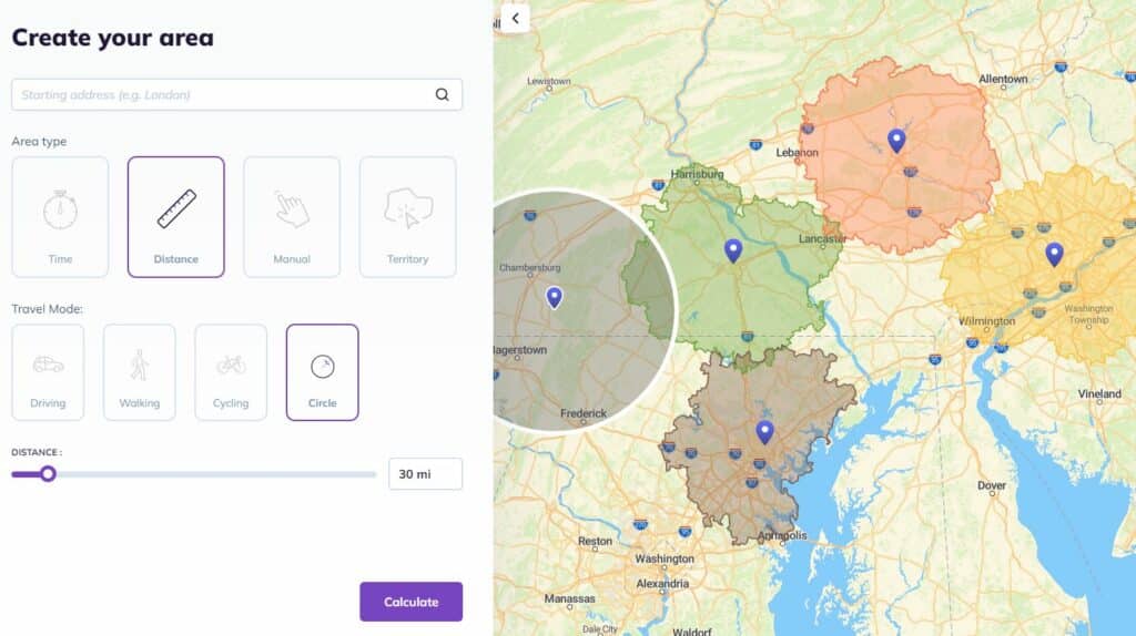
With Smappen, you just have to point a site location or a specific area you want to explore and you’ll draw a circle radius in unless 1 minute in a few clicks!
- Go to Smappen app (free plan to use our map tool)
- Click on “Add an area”
- Define your starting point address to the map
- Select the “distance” mode
- And select the distance you need (in miles or kilometers)
- Then click “circle” to draw a circle radius
- Click on Calculate
Then on the right part, you can access to the list of every zip code (or postcode) included on the area.
Everything about Zip Code Radius
Understanding and utilizing zip code radii is essential for businesses looking to enhance their strategic planning, logistics, and marketing efforts. Tools like Smappen offer powerful features that allow businesses to visualize and analyze geographic data with ease. Whether you’re planning a franchise expansion, optimizing logistics, or conducting market research, smappen’s zip code radius and map calculator features provide the insights needed to make informed decisions and drive business success.
By integrating these geographic insights into your business strategy, you can unlock new opportunities for growth and efficiency, ensuring that your business stays ahead in today’s competitive landscape.
Explore the capabilities of Smappen and start transforming your business with precise geographic insights today.