TL;DR
- Isochrone maps show areas reachable within a specific time from a point, making them ideal for analyzing accessibility and customer reach.
- Radius maps display a fixed-distance circle around a location, useful for understanding market penetration but less dynamic than isochrones.
- Combining isochrone and population data provides a powerful tool for businesses to make informed decisions on location planning, marketing, and customer engagement.
Understanding the dynamics of geographic data is crucial for any business, whether you’re running a local store, managing a franchise, or planning to expand. Two of the most valuable tools at your disposal are isochrone maps and radius maps. These tools help you visualize and analyze geographic areas, but they serve different purposes. In this article, we’ll dive deep into what each map type offers, how they differ, and how you can leverage them to grow your business.
What Is an Isochrone Map?
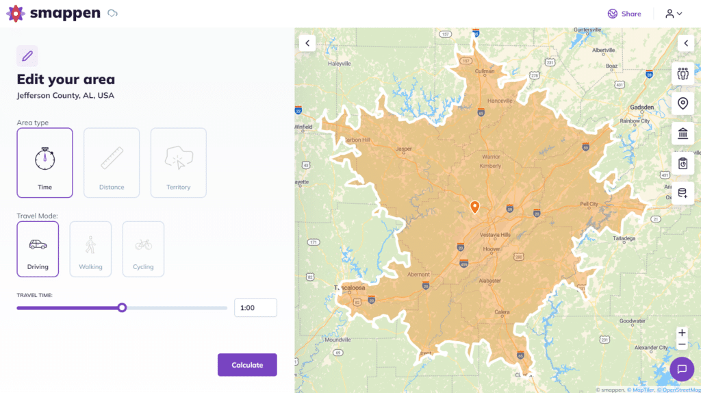
An isochrone map is a powerful tool that shows you the areas that can be reached within a certain amount of time from a specific location. Imagine you’re a business owner and you want to know how far a customer can travel to your store within 10 minutes. It will give you that information. The map is divided by lines or shapes that connect points of equal travel time, usually by car, bike, or foot.
Advantages of Isochrone Maps for Your Business
- Enhanced customer reach analysis: by understanding how far customers are willing to travel, you can optimize your location’s accessibility.
- Targeted marketing: focus your advertising efforts on areas where customers can easily reach your business, ensuring better ROI.
- Optimized service areas: if you’re offering delivery or in-home services, knowing your isochrone can help you plan routes and set realistic service boundaries.
When to Use Isochrone Maps
Isochrone maps are ideal when time, not distance, is the key factor in your business decisions. For example, a coffee shop might use an isochrone map to determine the best spot to place billboards or direct mail campaigns. If your customers are likely to walk or drive within a specific time frame, this map will provide the most accurate representation of your true market area.
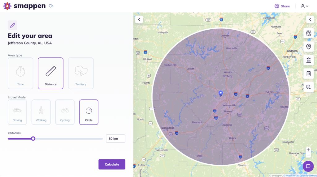
What Is a Radius Map?
On the other hand, a radius map is a simpler tool. It shows a circle around a location that represents a fixed distance. If you draw a 5-mile radius around your store, the map will display a circle with a 5-mile radius around your location.
Advantages of Radius Maps for Your Business
- Simple market penetration analysis: a radius map gives a quick snapshot of how far your business reaches in all directions.
- Competitor analysis: aasily visualize your competitors within a certain distance to understand your market saturation.
- Catchment area determination: for businesses like gyms or retail stores, knowing the geographic catchment area is crucial for planning promotions and customer acquisition strategies.
When to Use Radius Maps
Radius maps work well when distance is more important than time. If you’re interested in knowing how many potential customers live within a 5-mile radius of your location, a radius map provides a clear answer. They’re also useful for understanding coverage areas for businesses that rely on proximity, like local retail stores or fitness centers.
Key Differences Between Isochrone and Radius Maps
While both tools help you understand geographic areas, they do so in different ways:
- Isochrone Maps consider time-based accessibility. They answer the question, “How far can someone travel in 10 minutes?”
- Radius Maps are about fixed distances. They answer the question, “How many miles away is something?”
The primary difference lies in how they treat space and accessibility. Isochrone maps take into account real-world factors like traffic, road networks, and travel speed. Radius maps, however, treat all directions as equal, ignoring any geographical or infrastructural barriers.
Why Isochrone Maps Are Often More Accurate
In real life, not all miles are created equal. A 5-mile drive in a congested urban area could take 20 minutes, while the same distance in a rural area might take only 5 minutes. Isochrone maps capture these nuances, making them a more accurate tool for businesses that need to understand true customer accessibility.
For example, if you’re opening a new restaurant in a city, using an isochrone map will give you a better sense of which neighborhoods are within a quick drive or walk. This can be crucial for making decisions on location, marketing, and even the type of services you offer.
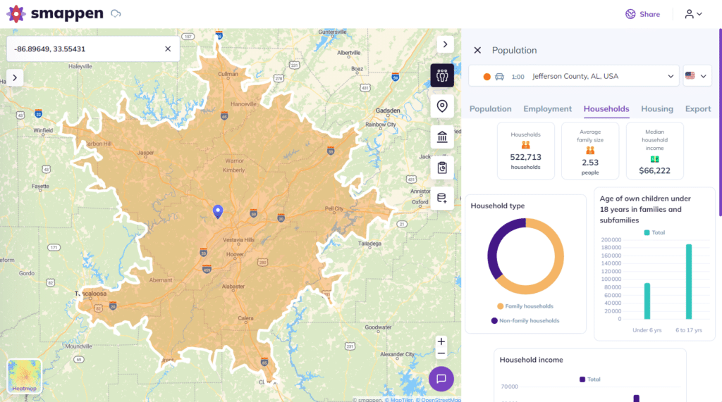
Combining Isochrone and Population Data: A Game Changer
Imagine if you could not only see how far your customers are willing to travel but also understand the population density within that area. That’s where combining isochrone maps with population data becomes a game changer.
How to Combine Isochrone and Population Data
By overlaying population data on your isochrone map, you can identify high-density areas where people are likely to visit your business. This approach helps you:
- Identify hotspots: find areas where high population density overlaps with easy accessibility.
- Target high-potential areas: focus your marketing and service delivery in areas where you can reach the most people.
- Make data-driven decisions: optimize your business strategy based on both accessibility and demographic information.
Use Cases for Businesses
- Retail stores. Understand where the bulk of your potential customers live and how far they’ll travel to shop with you.
- Franchises. Determine the best locations for new outlets based on travel time and population clusters.
- Service providers. Plan efficient routes and service areas by considering both customer density and travel time.
The Smappen Advantage: Bringing Isochrone Maps to Life
Smappen is a mapping tool that makes creating and analyzing isochrone maps simple. Whether you’re a small business owner or a franchisor, Smappen allows you to visualize the areas your customers can reach within specific time frames. You can easily overlay population data, helping you make informed decisions about where to focus your efforts.
Key Features of Smappen
- User-Friendly Interface, you don’t need to be a GIS expert to use Smappen. Its intuitive design makes it easy for anyone to create detailed isochrone maps.
- Customization, adjust travel times, transportation modes, and other parameters to fit your specific needs.
- Data Integration, combine isochrone maps with population data, income levels, and other demographics to gain deeper insights.
Practical Examples: How Businesses Are Using Smappen
Example 1: Finding Expansion Opportunities
Example 2: Competitive Analysis
Example 3: Logistics and Marketing Strategy
Choosing the Right Map for Your Business Needs
So, which map should you use? The answer depends on your specific business needs:
- Use an isochrone map when you need to understand accessibility based on travel time.
- Use a radius map when you need a simple, distance-based analysis of your market area.
- Combine isochrone maps with population data for a comprehensive view that helps you make informed, strategic decisions.
Both tools have their place in business planning, and by using them together, you can gain a deeper understanding of your market and make smarter decisions.
FAQ's
An isochrone map shows areas that can be reached within a certain time from a specific point, considering factors like traffic and road networks.
A radius map shows a fixed-distance circle around a point, while an isochrone map shows the area reachable within a specific travel time.
Combining these data helps you identify high-potential areas where accessibility and population density overlap, leading to more informed business decisions.
Yes, Smappen is designed to be user-friendly, with an intuitive interface that allows anyone to create detailed isochrone maps.